

1. Introduction
2. Literature Review
3. Methodology
3.1 3D Modeling
3.2 Sensor Data Integration and Automation
3.3 Visualization and Information and Management
4. Results and Discussion
5. Conclusions
1. Introduction
Concrete is one of the most used materials for road construction because of its structural flexibility and durability (Liu et al., 2017). It is especially preferred for highways, bridges, and other major infrastructure projects due to its capacity to withstand heavy loads. Additionally, concrete's ability to absorb and redistribute stress contributes to its reputation as a durable material. Although durable, concrete is vulnerable to damage from vehicle loads and other factors, leading to potential structural failures over time (Plati, 2019). Small cracks in the concrete, if not addressed, have the potential to widen and lead to more significant damage, necessitating expensive repairs and presenting safety hazards to drivers (Bučko et al., 2022). As a result, the traditional approach of reactive road maintenance, or the addressing of problems only after visible damage has occurred, is no longer sufficient. There exists a pressing need for early detection methodologies that enable infrastructure managers to recognize and mitigate potential damage prior to its escalation into a more critical issue (El-Maissi et al., 2020).
Embedded sensors are becoming increasingly important in road infrastructure as they enable real-time monitoring of structural health and facilitate early detection of damage. Unlike traditional reactive maintenance, these sensors support proactive solutions by providing continuous data on the condition of roads, helping to prevent severe deterioration. This real-time monitoring of data allows for timely intervention, which is especially beneficial for critical structures such as roads and highways. Integrating these sensors greatly helps infrastructure managers and other stakeholders gain a clearer understanding of concrete structures, paving way to more effective maintenance, earlier detection of problems, and improved access to difficult-to-reach or dangerous locations, ultimately contributing to safety of workers (Strangfeld et al., 2019). However, the effectiveness of maintenance and longevity of these assets are highly dependent on the accurate location and management of embedded sensors in road infrastructures. When sensors fail or exhibit performance degradation, the capacity to quickly and easily identify their location becomes essential and in the absence of accurate location data, maintenance personnel may experience delays and incur extra expenses while trying to locate and service the sensors (Panah and Kioumarsi, 2021). This inefficiency highlights the need for a system that continuously updates sensor locations for effective maintenance.
In line with this, studies have progressively turned to the use of Building Information Modeling (BIM), a comprehensive process and collaborative platform that creates data-intensive virtual 3D models of buildings. BIM allows for the management of a structure’s whole lifecycle, improving decision-making, and permitting stakeholders to easily access and disseminate accurate information (Kazado et al., 2019; O’Shea and Murphy, 2020). As road infrastructure becomes more complex, BIM is gradually relied upon for its ability to monitor sensory data and support real-time maintenance schedules, which help prevent unexpected failures. Traditional methods of managing embedded sensors often rely on static documents and manual processes, leading to inefficiencies and delays. In contrast, BIM's dynamic visualization and real-time updates ensure that infrastructure management is both proactive and responsive, helping to maintain road safety and reduce long-term costs (Valinejadshoubi et al., 2022).
While BIM has gained significant traction in the construction and infrastructure sectors as a tool for integrating, managing, and visualizing data throughout a project’s lifecycle, its application to sensor management in road infrastructure remains underexplored. In road infrastructure, combining BIM with embedded sensor technology presents an opportunity to develop real-time, data-driven models of roads and highways, incorporating both structural and sensor information. Such integration could transform road maintenance by automating processes, supporting timely maintenance, and enabling proactive, long-term infrastructure management (Valinejadshoubi et al., 2022).
Despite its potential, the integration of BIM with embedded sensors, particularly in large-scale infrastructure projects, poses significant challenges, especially regarding the complexity of data handling and the need for scalability. Extensive road networks consist of numerous embedded sensors collecting real-time data on different variables and parameters, which must be processed and organized within BIM. Effectively managing large amounts of data requires systems that are adept at accommodating constant changes, such as sensor locations or configurations that may have resulted from resurfacing, repairs, or upgrades. Failing to manage this complexity risks the model’s accuracy and may lead to inefficiencies in data management and compromised data integrity. Another key challenge is the necessity for interoperability between diverse platforms and systems utilized by numerous stakeholders in different infrastructure projects. Engineers, contractors, maintenance teams, and government agencies may all utilize different software tools and data formats. For BIM to serve as a comprehensive tool for sensor management, it must be able to integrate data seamlessly from various sources, ensuring compatibility and real-time updates across different systems. Therefore, the development of standard protocols for data exchange and the ability to automate the integration of sensor data into the BIM environment without extensive manual intervention is required.
This study aims to address these challenges by developing a novel framework that integrates BIM with embedded sensor technology to manage sensor data across the entire lifecycle of road infrastructure. Leveraging platforms such as Revit and Dynamo, this framework will provide a scalable solution for intuitive visualization of sensor locations, automated maintenance processes, and efficient data management. Additionally, this approach will lay the foundation for future integration with emerging technologies like IoT, artificial intelligence (AI), and machine learning (ML), which have the potential to further enhance proactive infrastructure management through predictive maintenance and efficient decision-making.
2. Literature Review
Concrete, frequently used with asphalt in roads and highways, is considered an essential material for construction due to its durability, noise reduction capabilities, and maintenance effectiveness (Pan et al., 2019). However, despite these advantages, concrete on roads is highly vulnerable to damage caused by continuous vehicle loads and environmental stressors, such as temperature changes and moisture exposure (Plati, 2019). Studies have shown that small cracks are often the initial stage of concrete deterioration, which can evolve into more severe damage if left unaddressed. Cracks formed by the constant wear and tear from traffic can significantly compromise the structural stability of roads, necessitating frequent maintenance and repair (Bučko et al., 2022).
Ruiz and Guevara (2020) note that traditional road maintenance is largely reactive, addressing damage after it has occurred. This reactive approach increases long-term costs and accelerates deterioration. They emphasize the need for data-driven, proactive strategies to prevent damage before it worsens. Embedded sensors are key to this shift, providing real-time monitoring of critical factors such as stress, moisture, and temperature. This continuous data collection enables early detection of potential issues, allowing for timely interventions that prevent further damage. Furthermore, sensor data can be used in predictive models to forecast pavement performance, helping agencies prioritize maintenance based on risk (Kim et al., 2022). Sensors also enable automated responses to change conditions, improving the efficiency of maintenance operations. Overall, embedded sensors facilitate a proactive maintenance approach, reducing costs, enhancing safety, and extending the lifespan of road infrastructure.
Embedded sensors have been shown to significantly enhance infrastructure monitoring by enabling the continuous collection of real-time data on critical parameters such as stress, strain, temperature, and moisture levels (Ferreira et al., 2022). This real-time monitoring allows infrastructure managers to detect potential issues at an early stage, facilitating timely maintenance interventions. Ferreira et al. (2022) contrasted embedded sensors with traditional non-destructive testing (NDT) methods, which rely on periodic inspections and often fail to capture damage that occurs between inspection intervals. Embedded sensors, however, provide continuous monitoring, allowing damage to be identified before it becomes visible, leading to more proactive and cost-effective maintenance strategies. Further studies, such as Yan et al. (2017), have demonstrated the effectiveness of Wireless Smart Aggregate systems for detecting internal cracks in concrete, although they highlight the need for scalability in large infrastructure projects.
Another notable application is the use of optical fiber sensors in Structural Health Monitoring (SHM) which has been particularly effective in providing high-precision data for road and bridges. Fernandez et al. (2021) highlighted the effectiveness of optical fiber sensors in monitoring strain and deflections in concrete structures, which is crucial for early damage detection in road infrastructure. Nonetheless, limitations such as camera drift during monitoring and load control instability highlight the challenges of long-term sensor accuracy in complex environments. Similarly, Liu et al. (2017) developed RFID sensors to monitor concrete temperature during critical construction stages, such as in pouring and curing of concrete. This system demonstrated how real-time data can be used in preventing temperature-related cracking, which ultimately enhances the durability of infrastructure. However, the lack of a reference clock and humidity-related communication issues suggest that further improvements in sensor reliability are necessary, especially when dealing with long-term sensor integration.
Despite the advantages of embedded sensors for road infrastructure, the management and maintenance of these sensors pose significant challenges. Over time, as road surfaces are resurfaced or repaired, the locations of embedded sensors can move due to wear, resurfacing, or repairs, making them difficult to locate. Park et al. (2021) underscored the risks of sensor damage during routine maintenance when the exact locations of sensors are unknown. This scenario illustrates the critical need for automated systems that can continuously update sensor locations, thereby reducing the risk of accidental damage during maintenance operations.
To address these challenges, BIM has emerged as a promising solution in various infrastructure sectors. BIM provides a dynamic platform for tracking sensor data and offering real-time visibility into sensor locations. Several studies have explored the advantages of BIM in managing infrastructure projects. BIM's capacity for data integration and collaboration has been shown to significantly enhance both the design and maintenance phases of infrastructure. For example, Kazado et al. (2019) demonstrated how integrating sensor technology with BIM and Navisworks improved data availability and enabled real-time monitoring, particularly through 3D visualization of sensor data. However, they also noted the difficulties of customizing BIM systems for older infrastructure. Similarly, O'Shea & Murphy (2020) integrated SHM systems with BIM for historic structures, such as the Kish Lighthouse, using Dynamo scripts to visualize real-time sensor data. While they highlighted BIM’s ability to manage sensor data in complex environments, they also acknowledged limitations in representing custom sensors.
BIM’s application has expanded beyond traditional building construction to road infrastructure management, where it now enables the integration of embedded sensor data with 3D models of road systems. Valinejadshoubi et al. (2022) demonstrated how BIM, combined with Revit and Dynamo, enhances real-time decision-making, streamlines maintenance, and reduces downtime. While these benefits are highly relevant to large-scale infrastructure systems like road networks, challenges remain in scaling BIM for larger projects, particularly in handling vast amounts of sensor data and automating workflows.
To overcome the challenges of scalability and real-time data processing, emerging technologies such as the Internet of Things (IoT), Artificial Intelligence (AI), and Machine Learning (ML) offer promising solutions. Looking forward, the integration of these technologies with BIM is expected to revolutionize infrastructure management. These technologies have the potential to significantly enhance the capabilities of embedded sensors by enabling predictive maintenance and real-time decision-making. Scianna et al. (2022) explored the concept of digital twins, where real-time sensor data continuously updates digital replicas of physical infrastructure, allowing for simulations that can predict future damage and optimize maintenance schedules. Although the integration of IoT and AI with BIM offers promising possibilities for improving infrastructure management, these technologies are still in their early stages. Kazado et al. (2019) identified challenges related to the integration of large volumes of sensor data into BIM platforms, emphasizing the need for more sophisticated algorithms that can process and analyze data in real-time. Additionally, significant barriers remain in terms of cost and compatibility with existing infrastructure systems.
Despite advances in embedded sensor technology and BIM, there remains a notable gap in the development of scalable, real-time systems for managing sensor data throughout the entire lifecycle of road infrastructure. Existing studies primarily focus on the benefits of individual technologies but often fail to address the challenges associated with integrating these systems into large-scale road networks. Furthermore, few studies have explored the potential of BIM for automating sensor tracking, which is essential for improving the efficiency of infrastructure maintenance. Both Valinejadshoubi et al. (2022) and Scianna et al. (2022) emphasize the importance of integrating BIM with IoT to enhance infrastructure management, though much work remains to fully realize the potential of these systems.
In response to these challenges, this study aims to develop a framework that combines BIM, embedded sensors, and automation tools to create a scalable, real-time solution for managing road infrastructure. By integrating sensor data with BIM platforms such as Revit and Dynamo, the framework will enable infrastructure managers to dynamically track sensor locations, automate maintenance processes, and ensure data accuracy throughout the road’s lifecycle.
3. Methodology
The primary objective of this study is to develop a BIM-based sensor management system to optimize the management of sensor location and monitoring of roads throughout its lifespan. Through the integration of Autodesk Revit and Dynamo, this study focuses on accurately modeling the precise location of embedded sensors to facilitate efficient maintenance and management.
Revit, commonly used in the Architecture, Engineering, and Construction (AEC) industry, is well-suited for managing structural information and visualizing aspects of the monitoring process. Its ability to integrate various building elements and material properties is essential for accurate modeling and effective sensor data management throughout the infrastructure's lifecycle. However, Revit’s inability to natively import data from external sources, such as Excel, necessitates the use of Dynamo. This Revit plugin automates the input of sensor coordinates through visual scripting, significantly reducing manual effort and minimizing errors.
This system is structured around three fundamental components: 3D modeling, sensor data integration and automation, and visualization and information management.
3.1 3D Modeling
The first component, 3D modeling, is dedicated to the creation of precise, 3D models of road that include key elements such as pavement and substructures. This phase ensures the accurate integration of sensors into the road network, accurately representing the actual conditions of the infrastructure.
In addition to spatial accuracy, the modeling process integrates key material properties, structural specifications, and geometric configurations to ensure the precise representation of the road infrastructure. This level of precision is essential for enabling the 3D model to accommodate structural changes over time, such as resurfacing or modifications, without losing track of sensor locations or compromising their functionality. By establishing a highly accurate spatial framework, this component ensures that future sensor data integration remains both reliable and scalable.
Moreover, the 3D model provides the foundation for subsequent system components, ensuring that sensor data can be effectively integrated with the physical layout of the infrastructure. The visual accuracy of the road’s structural elements plays a critical role in facilitating a smooth transition between digital design and real-world application. This precision is especially vital for large-scale projects, where discrepancies between the model and the actual infrastructure can result in significant inefficiencies in maintenance and management.
3.2 Sensor Data Integration and Automation
The second component, sensor data integration and automation, facilitates the incorporation of sensor-related data—including sensor locations, identification numbers, and operational parameters—into the 3D model. Using Dynamo scripts, large datasets containing sensor coordinates and operational parameters are automatically mapped to their corresponding positions within the 3D model. This automation not only reduces reliance on manual data entry but also significantly minimizes the risk of human error, ensuring that sensor information remains continuously updated as the infrastructure evolves over time.
The integration process begins with the collection of sensor data (e.g., geographic coordinates, sensor IDs) in Excel spreadsheets, which serve as the primary data source for automation. A custom Dynamo script (illustrated in Figure 1) automates the extraction and integration of this data into the BIM environment. The Excel.ReadFromFile node efficiently imports the sensor data into the system, reducing the manual effort typically required for data input. To ensure data integrity, the imported datasets are cleaned and filtered using the List.Clean node, which eliminates erroneous or duplicate entries. The data is then reorganized using the List.Transpose node, aligning it with Revit’s parameters to guarantee consistency and accuracy during data integration.
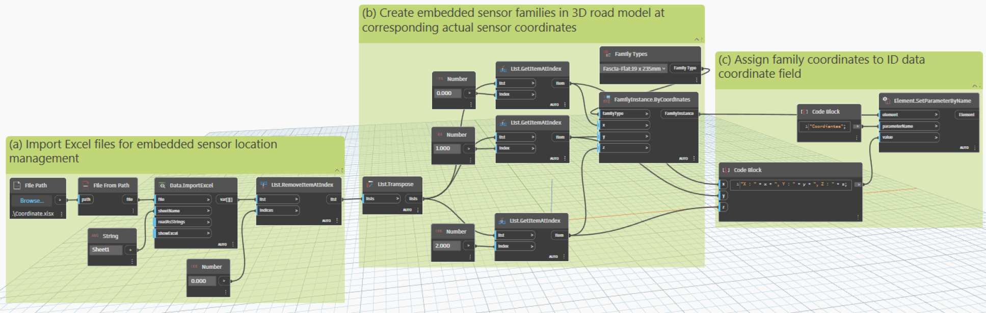
Once structured, the FamilyInstance.ByCoordinates node automates the precise placement of sensor objects within the BIM model, matching each sensor’s geographic coordinates. This automated placement ensures efficient and accurate deployment of sensors, a task that would otherwise be highly labor-intensive if done manually. Following placement, each sensor object is associated with metadata (e.g., operational status and maintenance schedules) through the Element. SetParameters and File.System.GetDirectoryContents nodes. This integration links each sensor to the necessary attributes for future monitoring and maintenance activities, providing a dynamic, real-time overview of sensor performance.
By streamlining the data entry and sensor placement processes, the automation framework enhances both the efficiency and accuracy of sensor management. This system allows infrastructure managers to continuously track sensor performance and quickly identify potential issues, such as sensor malfunctions or positional shifts caused by structural changes. For large-scale projects involving extensive sensor networks, this automation ensures consistent and reliable data management, contributing to the long-term sustainability and operational efficiency of road infrastructure maintenance.
3.3 Visualization and Information and Management
The final component, visualization and information management, focuses on leveraging Revit’s advanced 3D visualization capabilities to provide an interactive platform for accessing and managing sensor data within the BIM environment. This component allows users to select individual sensors directly within the model to retrieve detailed information, such as latitude, longitude, elevation, and other relevant metadata. This functionality is crucial for infrastructure managers and engineers, as it enables the efficient identification of compromised sensors or areas that may require attention, thereby facilitating timely maintenance interventions.
By continuously updating sensor data in response to changing road conditions, the framework ensures visibility into sensor locations and operational statuses. The system tracks sensor positions over time, maintaining accurate information even after road modifications such as resurfacing or repairs. This functionality enables infrastructure managers to make informed, data-driven decisions based on the comprehensive view of sensor data within the broader infrastructure model.
Additionally, the centralized platform enhances collaboration between stakeholders, promoting more coordinated infrastructure management. The system’s ability to visualize sensor data within the context of the entire road network is particularly valuable in emergency situations, where rapid responses are critical. This framework improves the efficiency of sensor placement and data management, enabling proactive maintenance, reducing the risk of critical failures, and promoting the long-term sustainability and safety of road infrastructure while minimizing maintenance costs.
4. Results and Discussion
The development of the BIM-based sensor location management framework using Revit-Dynamo integration effectively addresses the limitations of traditional sensor management methods, which often rely on static Excel spreadsheets and paper-based documentation. This automated system ensures precise and efficient management of sensor data throughout the lifecycle of road infrastructure, demonstrating its feasibility as a proactive approach and providing significant improvements over existing methods.
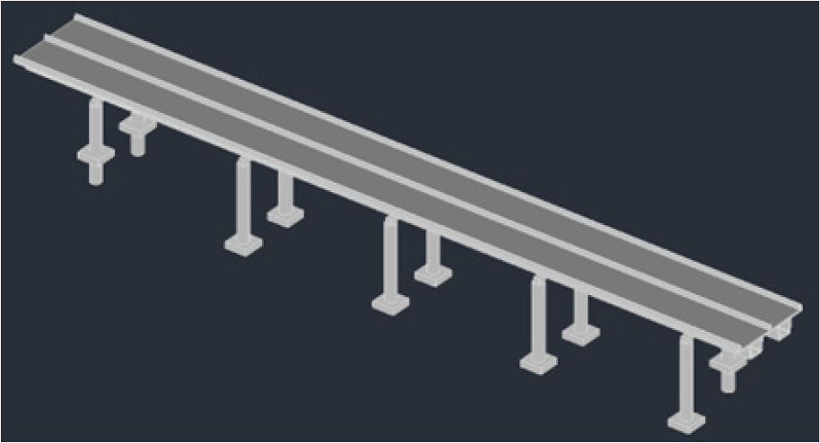
As shown in Figure 2, the 3D model of the road infrastructure, including its substructure, serves as the foundation for sensor integration. An accurate model is essential for ensuring precise spatial representation of both the structure and the sensors. By establishing a comprehensive 3D environment, the framework enables the accurate placement of sensors, which is critical for monitoring their status and maintaining both the sensors and the structure over time. Banfi et al. (2017) highlights the importance of precision in 3D modeling for integrating sensor data into BIM environments, emphasizing that without an accurate base model, the placement and monitoring of sensors may be inconsistent. This underscores the value of the proposed framework, where the creation of a highly accurate 3D model of the road infrastructure forms a crucial step toward effective sensor placement and long-term monitoring.
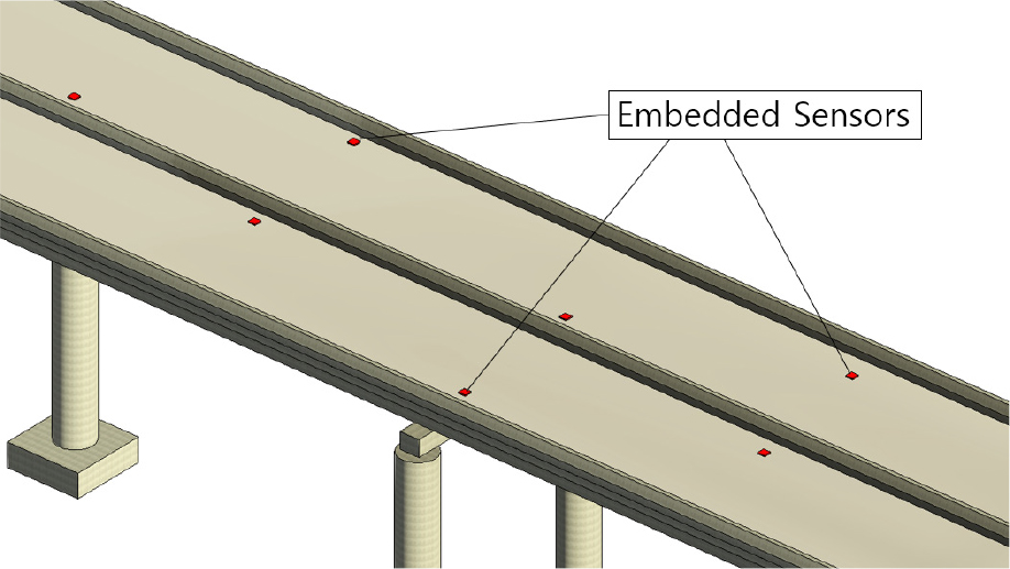
Once the 3D model is established, the framework moves to sensor integration using Dynamo scripts. These scripts automate the placement of embedded sensor families within the Revit model, processing coordinate data imported from an external file, typically Excel. Dynamo reads the sensor location data and generates the corresponding 3D family instances at precise coordinates within the model. Additionally, it updates the relevant family parameters and ID fields, ensuring that all sensor data is accurately reflected and stored for future analysis. Figure 3 visualizes the results of this automated process, where sensor families are accurately placed within the model. By automating sensor placement, the framework addresses challenges highlighted in previous studies, such as the complexities involved in managing large sensor networks manually (Valinejadshoubi et al., 2022).
Automation of sensor placement enhances infrastructure management by enabling early detection of potential issues and optimizing resource allocation, ensuring timely maintenance interventions. This automation not only reduces human errors associated with manual sensor integration but also facilitates proactive infrastructure maintenance, ensuring the system remains responsive to real-time conditions. The use of automated scripts streamlines the process, making it scalable and applicable to large road infrastructure projects, which would otherwise be prone to inefficiencies with manual sensor management approaches.
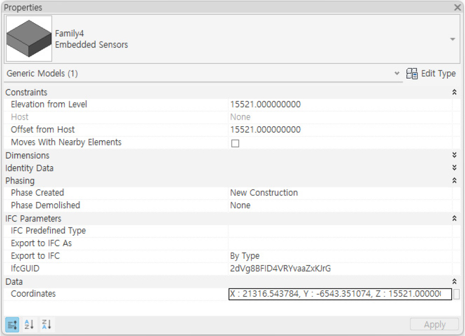
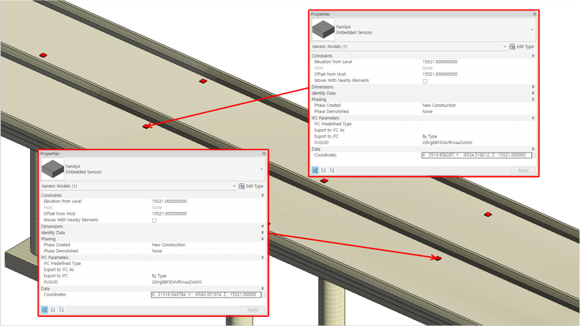
A key advantage of this framework is its ability to visually represent sensor data within the BIM model, as demonstrated in its third phase. The framework has so far imported properties like geographical coordinates as seen in Figure 4, but it is scalable to include additional attributes such as site and sensor photos, maintenance data, and descriptions, thereby enhancing the depth of data available to users. Bučko et al. (2022) emphasize the importance of effective data visualization in engaging stakeholders by providing clear and accessible representations of infrastructure conditions and maintenance needs. BIM’s interactive 3D models and consistent data integration facilitate collaboration, enabling stakeholders to make informed decisions on maintenance strategies. The framework’s interactive environment further enhances engagement, offering information that helps engineers and facility managers to make data-driven decisions regarding maintenance, repairs, and resource allocation.
Furthermore, the use of Revit-Dynamo automation bridges a significant gap between the tools used during construction and those required for long-term maintenance. Kazado et al. (2019) notes that while BIM tools such as Navisworks are commonly used during construction, they are often neglected during the operational phase of infrastructure projects, leading to inefficiencies in long-term management. The proposed framework resolves this issue by ensuring that sensor data remains integrated within the BIM model throughout the infrastructure's lifecycle, making it adaptable for ongoing maintenance needs.
The system further highlights proactive maintenance through its centralized, interactive platform. Figure 5 illustrates how users can access and visualize sensor attributes within BIM. This platform provides a unified view of infrastructure data, enabling more informed decision-making by stakeholders. Valinejadshoubi et al. (2022) highlight the importance of centralized platforms in infrastructure monitoring, pointing out that current systems often lack comprehensive data integration. The proposed framework fills this gap by offering an integrated solution solution where stakeholders can manage issues proactively, ensuring early identification and resolution to prevent escalation into more significant problems.
By providing a centralized platform, the framework also supports long-term sustainability in road infrastructure management. While full integration of real-time data sources like IoT remains a challenge, as noted by Kazado et al. (2019) and Valinejadshoubi et al. (2022), the current system offers a practical and scalable solution for immediate improvements. As demonstrated in Scianna et al. (2022), integrating IoT technologies can further enhance monitoring capabilities by providing continuous data flow and real-time feedback. Future enhancements to the framework, such as incorporating IoT data, could optimize resource utilization and reduce environmental impact by improving operational efficiency in road infrastructure projects.
However, the study faced challenges, particularly related to the quality of data input. The success of the automation process relied heavily on the accuracy of the Excel files, and any errors required manual correction before data could be integrated into the model. While Dynamo scripts automated sensor placement, they lacked the flexibility to selectively modify parameters for individual sensors, requiring script adjustments whenever specific details needed updating. This highlights the need for further refinement to improve flexibility.
Despite these challenges, the BIM system offers a centralized, dynamic repository for sensor information, supporting proactive maintenance planning. Users can access actual sensor updates, ensuring data consistency across stakeholders, which is crucial for efficient road infrastructure management. The system's flexibility also allows the integration of additional information, such as sensor types, environmental conditions during installation, and performance metrics, providing valuable insights for future maintenance and operational improvements.
In summary, the proposed framework offers a significant contribution to road infrastructure management by providing a scalable, accessible platform for managing sensor data within a BIM environment. Through accurate 3D modeling, automated sensor placement, and centralized monitoring, the system enhances maintenance efficiency and stakeholder engagement by integrating sensor data into decision- making. By addressing the limitations of manual documentation methods, the framework enables road infrastructure projects to adopt more proactive, data-driven management strategies. With the flexibility to incorporate future advancements, such as IoT integration, the framework is well- positioned to improve road infrastructure management.
5. Conclusions
This study proposes a BIM-based framework for road maintenance management, focusing on the precise tracking and maintenance of embedded sensors using Revit and Dynamo. The framework addresses limitations of traditional sensor management methods, providing a more accurate and efficient solution as road surfaces degrade over time. Key outcomes and implications are summarized as follows:
• Automation and Efficiency: The integration of sensor data within a dynamic 3D BIM environment automates the placement and management of sensors, significantly reducing manual errors and improving overall operational efficiency.
• Proactive Maintenance: The system supports proactive maintenance by providing real-time sensor data, enabling timely interventions that reduce costs and enhance road safety.
• Visualization and Stakeholder Engagement: The framework provides clear visual representations of sensor data in a 3D model, improving collaboration and decision-making among stakeholders by offering real-time insights into infrastructure conditions.
• Scalability: The framework is adaptable to other infrastructure types, such as bridges and tunnels, demonstrating its potential for broader applications beyond road maintenance.
Future research should focus on developing algorithms for sensor data analysis and establishing strong data management systems to further advance road monitoring systems. With ongoing research and refinement, the BIM-embedded sensor integration is expected to transform road maintenance practices, contributing to safer and more efficient infrastructure management.
